Easy trip assistance app
 by Roseann Hanson
How many times have you been reading a magazine or book, and come across some place you want to jot down to remember to visit, such as a landmark, a restaurant, a museum, or a trail?
In the past I either scribbled these onto a nearby post-it note or in a file on my computer. Inevitably these got lost in the shuffle of life, or are too difficult to locate when I knew I was going to be in a certain place, or I just plain forgot to bring my file with me.
Recently friends mentioned how interesting Scotty's Castle was on their overland trip through Death Valley. I started to jot it down in a notebook in the truck, but then thought, I wonder if there is an app for that?
Ever the fan (and growing) of organizing my life by iPhone, I searched the AppStore for "record places" or "remember places." One of the first to come up was the very promising My Places by VoyagerApps.com. Using your GoogleMaps account, it promises to let you see and organize your saved "places" in real time. I downloaded the free version to test it out, but unfortunately it was so annoying, I deleted it. The free version won't let you do anything without constant interruptions from pop-up notifications asking if you want to download and try other apps (presumably by VoyagerApps.com)—a different ad popped up every 30 seconds, literally, and you have to stop and click "No, thanks" every time. Then it would not let me save anything or see my Google places unless I bought the app, so I could hardly see if it worked or not. I don't mind buying apps, but this was a real stinker.
Then I tried a cool-sounding app called PintheWorld, which allows you to pin and save places of interest, give them categories (different colored pins, too), and see them when passing through a location. Sounded perfect! But unfortunately the developer uses the new iOS 6 in-house (and yes, totally lame) Apple Maps app and it is so inaccurate and picky, I could not find businesses I knew were there. The trick turned out to be that you have to type the exact, and I do mean exact, address down to the country and zip code. And then you have to manually name it and add details. Too much work. I just knew, with the power of the Internet and Apple, there had to be a solution.
Turns out it was right there all along: Google just released their brilliant Google Maps app for iPhone—pair it with your Google Maps account, and you're good to go.
(For those of you who haven't followed the little cyber drama between Google and Apple, Google was the original driver behind the superb Maps app on the iPhone but last year Apple and Google's relationship melted down, and Apple replaced Google as the data source with TomTom. My own side-by-side comparision between Google Maps and the Apple iOS 6 Maps bore out all the crazy criticism of the incredibly bad app. The famous tech geek David Pogue even called it "the most embarrassing, least usable piece of software Apple has ever unleashed." I could call up Google Maps, looking for the new Wanderlust Brewery in Flagstaff and up it pops . . . on Apple's Maps it fails to find anything, or sends me to Connecticut.)
But back to how to use the Google Maps and your Google account to save cool places to visit (after downloading Google Maps app you need to pair it with your online Maps.Google.com account).
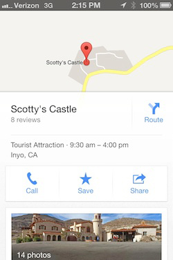
 I wanted to save Scotty's Castle as a place of interest, so I just hit the search bar, typed in Scotty's Castle, and up it pops (see screen shot, right). Swipe up on the name Scotty's Castle in the bar at the bottom, and it gives you a menu of buttons—Call, Save, Share. Hit Save, and it puts it into your Google Places.
On this screen you can also browse things like photos, hours, reviews, distance from current location, and other useful information.
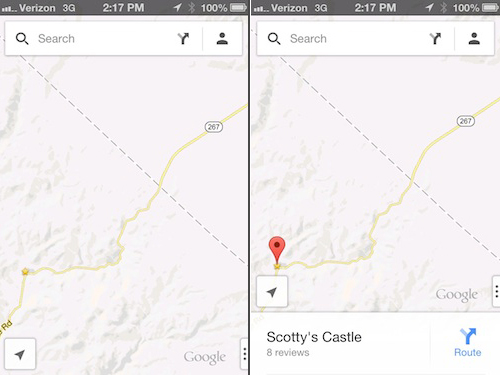
Then, next time I'm in Death Valley area, and I want to see if it's nearby, I fire up Google Maps app and any saved Places show up as yellow stars (see below).
I am trying to find out if the star colors can be changed, because the yellow is hard to see against the yellow roads. And they only show up at a certain zoom magnification.
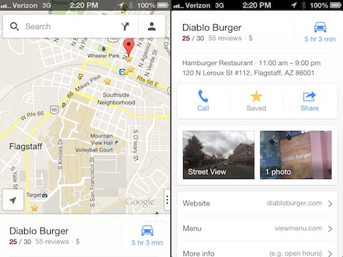
The next screen-shot set below shows all the restaurants and cafes saved for Flagstaff, near Overland Expo. Click on a star and a pin pops up; click on the pin and you get the easy-to-read information popup at the bottom (swipe it up to see the details).
Ideally Google will eventually let us categorize and organize our Places, and edit them from either the app or through the Maps.Google.com. It would be nice to filter for things like restaurant, art gallery, museum, trail, or other category, to help minimize clutter if you have marked a lot of places in one area.
But otherwise it looks like it's going to be a very useful tool for travel anywhere.

 Google Maps app is great for storing places you want to visit, like these restaurants and cafes in Flagstaff, near Overland Expo.
