Field Arts Workshop: Layout Strategies for Beautiful (Organic) Pages

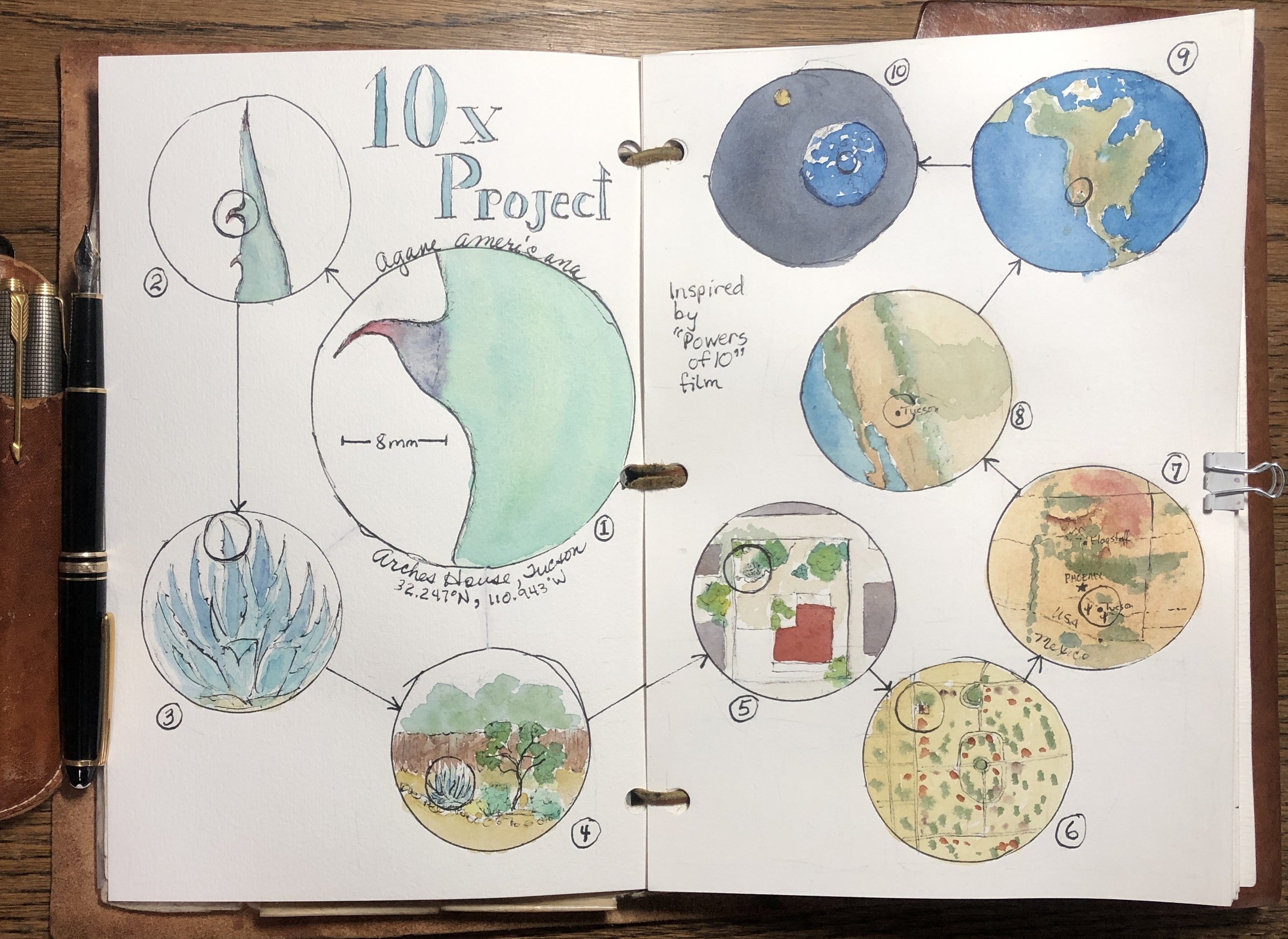
Tennis star Arthur Ashe famously said: “There is a syndrome in sports called ‘paralysis by analysis.’” The same is true for art. A study published in the Journal of Neuroscience found that the prefrontal cortex—which is housed in the cerebrum—is the part of the brain responsible for planning, executive function, and working memory. Further, the findings showed that overactivity in the prefrontal cortex can interfere with brain processes necessary to perform fluidly; simply put, this can cause people to “choke,” whether you are an athlete or an artist.
This fun and inspiring workshop is going to focus on how we “loosen up” and let go of Type-A-style planning so that our pages become beautiful in an organic way, enhanced by our science-oriented data—which is the most beautiful thing of all.
We’ll also have some fun with a few tools and tricks: a caliper to measure proportions (which happen to coincide with the “Golden Mean” . . . don’t worry we’ll cover that, too!) and a fun protractor for making perfect circles.
Length: 2 hours
Resources from the Workshop
Handout with images, tips and links: https://www.dropbox.com/s/swadhrq8gdms0mg/Organic%20Page%20Layout%20-%20Final%20PDF%20Roseann%20Hanson.pdf?dl=0
CHAT transcript — click > HERE <
Click to initiate download of a PDF of the workshop presentation (50mb file): https://www.dropbox.com/s/cwglitp4269b6n0/Organic%20Layout%2012-04-2021.pdf?dl=0
Links from the workshop:
Virtual Field Trip to Arctic Alaska: https://360exploring.s3.us-west-1.amazonaws.com/Arctic+Alaska/output/index.html
Helix Round Protractor:
From the Field Arts shop, in the Discovery Kit: https://www.exploringoverland.com/field-arts-shop
From Amazon, search for “Helix Round Protractor”

Screen shot of the Virtual Field Trip to Arctic Alaska by Roseann Hanson
Layout sketch idea #1

Layout sketch idea #2
Field Arts Workshop: Weather 101 for Field Notebooks
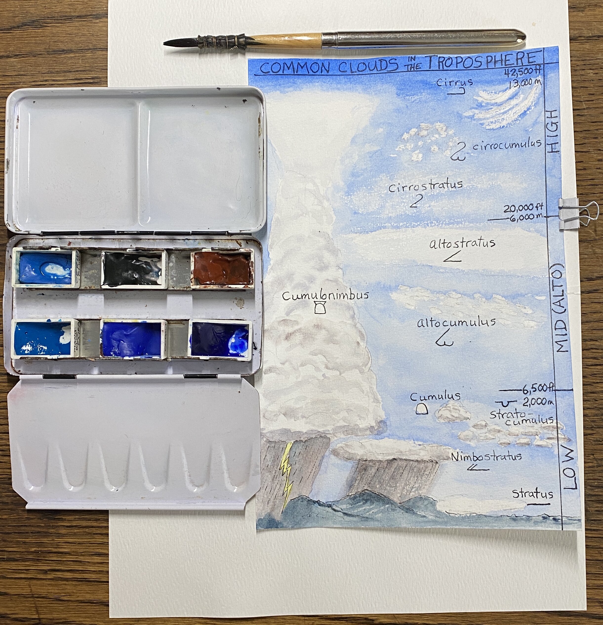
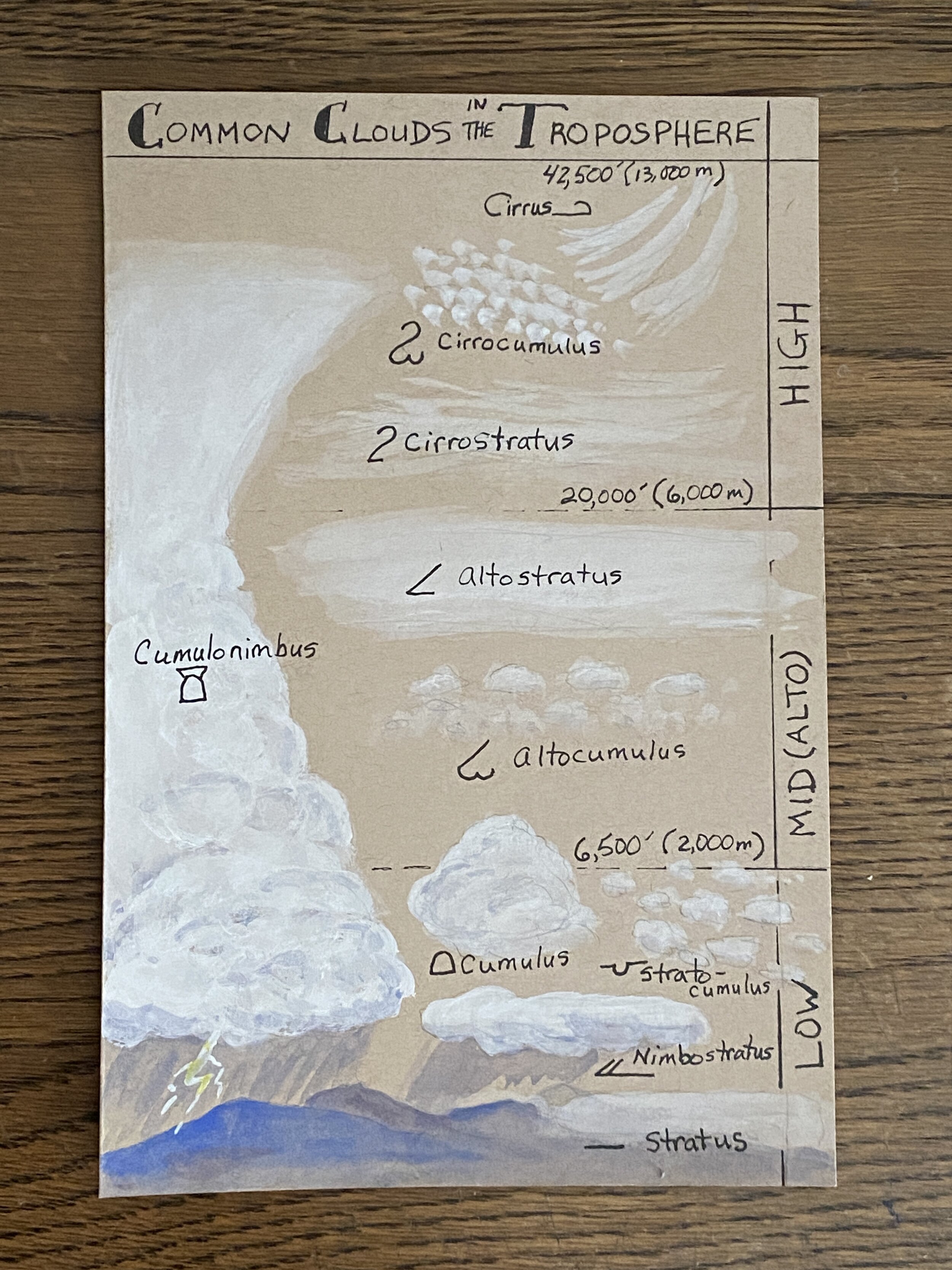
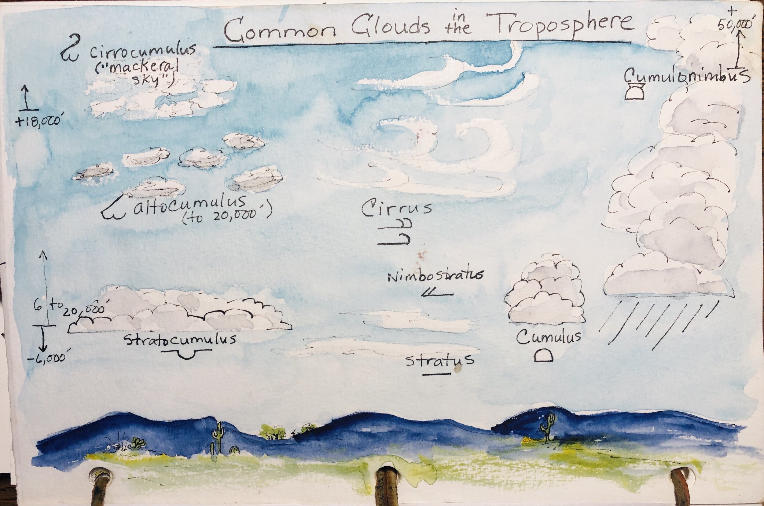
Creating a cloud ID chart is a great way to practice cloud-painting skills as well as to learn the main cloud types.
Metadata for your field notebooks is a crucial addition, to give your entries a solid foundation in context: date, time, sunrise / sunset, moon phase, and weather. Weather is fun to learn: What are the clouds? How do you ID them? How do you tell the wind speed? What are the symbols for recording weather?
In this free Field Arts tutorial, we will dive into learning about weather data, what is climate vs. weather, where weather forms and how, and how to ID clouds. Then we’ll create a cloud-chart that you can keep in your journal for future reference.
Length: 2 hours
Resources from the Workshop
pdf with all links and download link for images and ALL THE charts (CLICK IMAGE):

Click image to initiate download. Or, use: https://www.dropbox.com/sh/rvlzr0a9hezdgjr/AACw6pH9jwhj6sQ-rvmM_GGwa?dl=0
SUGGESTED PAINTS AND SUPPLIES:
Ruler and pencil
Pen with waterproof ink
And for the color, two approaches:
1) Traditional:
- watercolor paper (9x6 or larger), at least 90 pound
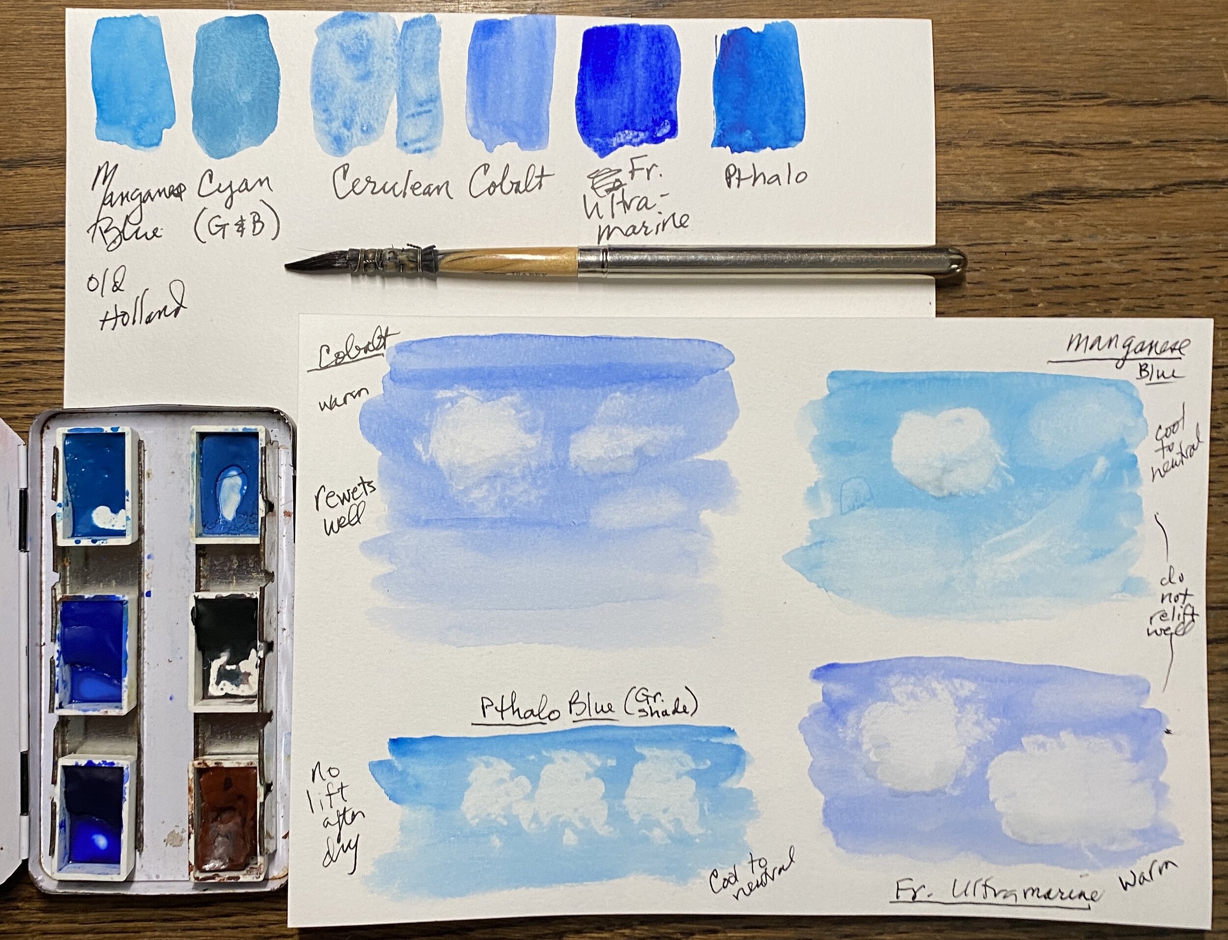
- cobalt or cerulean; these are pretty and wash easily, and also lift easily. French ultramarine is wonderful but does not lift as well and does granulate a little, so it will settle into the texture on your paper, which you may or may not like.
- burnt sienna to mix with your blue to create a nice gray for the clouds
- alternatively, shadow violet
OR
2) gouache:
- toned paper (dark grey or tan)
- gouache paint in white and blue and burnt sienna
I actually found the toned with white gouache to be much easier for this chart exercise!


You can find my list of minimalist colors and tips on color mixing here: https://www.exploringoverland.com/field-arts-tutorials-list/2020/7/5/minimalist-watercolor-for-nature-journaling
COLORS I DEMONSTRATED:
Manganese Blue (Old Holland)
Cyan (Greenleaf & Blueberry)
Cobalt (Daniel Smith)
Cerulean (Daniel Smith)
French Ultramarine (Daniel Smith)
Pthalo Blue (Green Shade, Daniel Smith)
Goache Set from Caran D’Ache (white, yellow, blue, red, burnt sienna)
This is the reference image for creating your own cloud chart for your journal.
Field Arts Workshop: Animal Tracking 101 for Field Notebooks
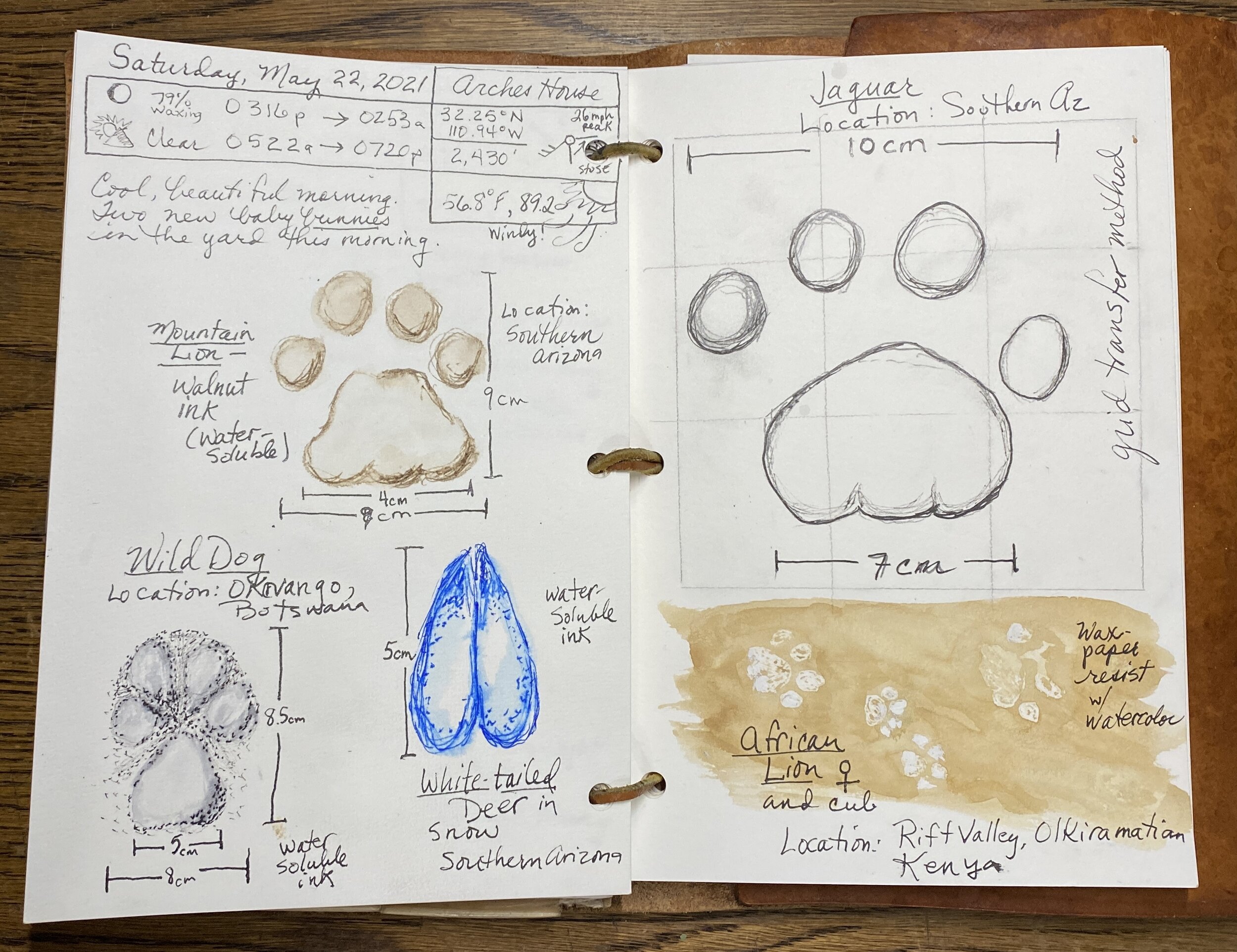
Female lion and cub tracks, Great Rift Valley, Olkiramatian, Kenya (click to enlarge).
Join me for a free online workshop on the basics of animal tracking—and different ways to add them to your field notebooks and nature journals. I’ve spent 30 years tracking wildlife and teaching tracking for conservation groups, and my husband Jonathan Hanson and I wrote the Basic Essential Guide to Animal Tracking.
Learn how to quickly tell canine from feline tracks, domestic dogs from wild, different gait patterns, and how to “read” a track story.
I’ll also show how to use my clear Perspex Palette-Easel ) to trace a track, and a template for making your own unique track ruler, as well as a free Quick Tracking Tips card.
Length: 2 hours
SEE BELOW FOR
Resources from the Workshop
Perspex palette: Head out to your local hardware store such as Ace Hardware and they should have a section where they sell clear polycarbonate (perspex) sheets and will cut them to size for you. Price depends on size, but around $10. If you want to use the sheet as a holder for a metal paint kit, add a strip of magnet tape.
Or, you can order from my shop (there may be a delay in shipping these in March 2025). See below.


Here’s a free printable tracking ruler, or order the same plastic original one that I use in the workshop, from Sue Morse at KeepingTrack.org. Sue is one of my tracking mentors. Her book is amazing, and recently updated.
Downloads (Tracking Tips Bookmark and Tracking Ruler) — IMPORTANT: These will open in Dropbox; click the DOWN ARROW in the upper right (it’s small); a box will open trying to get you to sign in or sign up but click the sentence underneath that to Continue Without.
Double-sided small card of tracking tips. Click to download PDF.
DIY tracking ruler with instructions. Printable PDF. Click to download.
Tip: Laminate the tracking ruler and the Quick Track ID card to make them more useful in the field.
field guides:
“Basic Illustrated Animal Tracks” by Roseann and Jonathan Hanson https://www.amazon.com/Basic-Illustrated-Animal-Tracks/dp/1493017179
The two best deep-dive tracking training books:
Paul Resendez, “Tracking and the Art of Seeing” https://www.amazon.com/Tracking-Art-Seeing-Animal-Tracks/dp/0062735241
and Sue Morse, “Wildlife and Habitats” https://keepingtrack.org/keeping-track-store
Good in depth basic field guides:
“Scats and Tracks of the Desert Southwest” by James C. Halfpenny, illustrations by Todd Telander https://www.amazon.com/Scats-Tracks-Desert-Southwest/dp/1560447869
and
https://www.amazon.com/Mammal-Tracks-Sign-American-Species/dp/0811737748
Recommended in the chat:
Oldie but goodie: Animal Tracks by Olaus J. Murie, Peterson Field Guide Series. Love the line work and clear illustrations.
“Mammal Tracks & Sign” by Mark Elbroch
For kids: John Townsend “Life-Sized Animal Tracks”
Animal Tracks of Alaska by Sheldon and Hartson is a handy little guide to take with you, has info on many different animals including common birds and amphibians.
“Foundations for Awareness, Signcutting and Tracking” - Robert Speiden
John Rhyder’s Animal Tracks Field Guide (stipple drawings of tracks in United Kingdom) https://www.woodcraftschool.co.uk/books
Wild Tracks!: A Guide to Nature's Footprints - is another good kids book
Leslie Dendy’s “Tracks, Scats and Signs” (Take Along Guides)
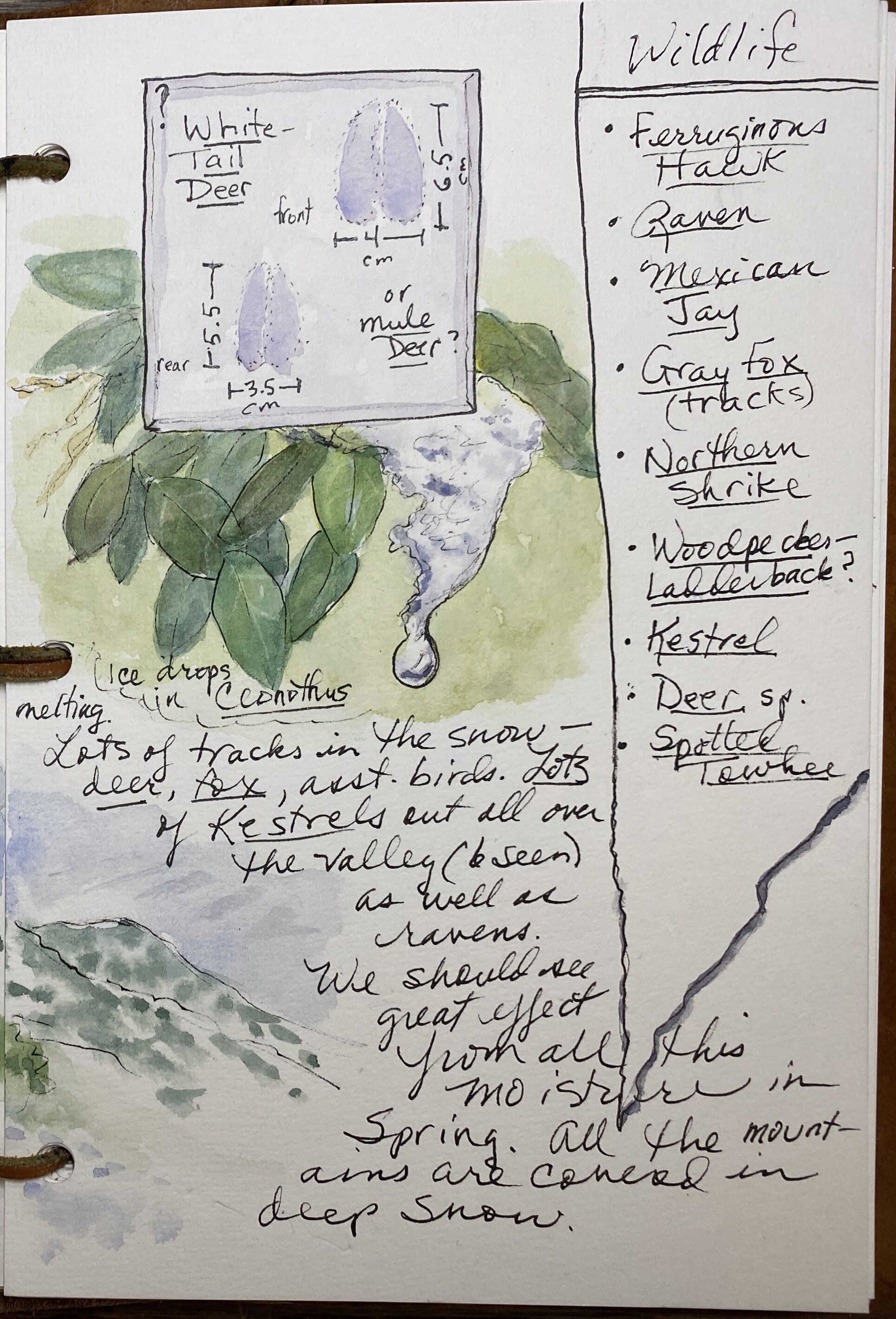
ROSEANN’S DEMO PAGES FROM THE WORKSHOP:
You can find my list of minimalist colors and tips on color mixing here: https://www.exploringoverland.com/field-arts-tutorials-list/2020/7/5/minimalist-watercolor-for-nature-journaling
ROSEANN’S DEMO IMAGES FROM THE WORKSHOP:
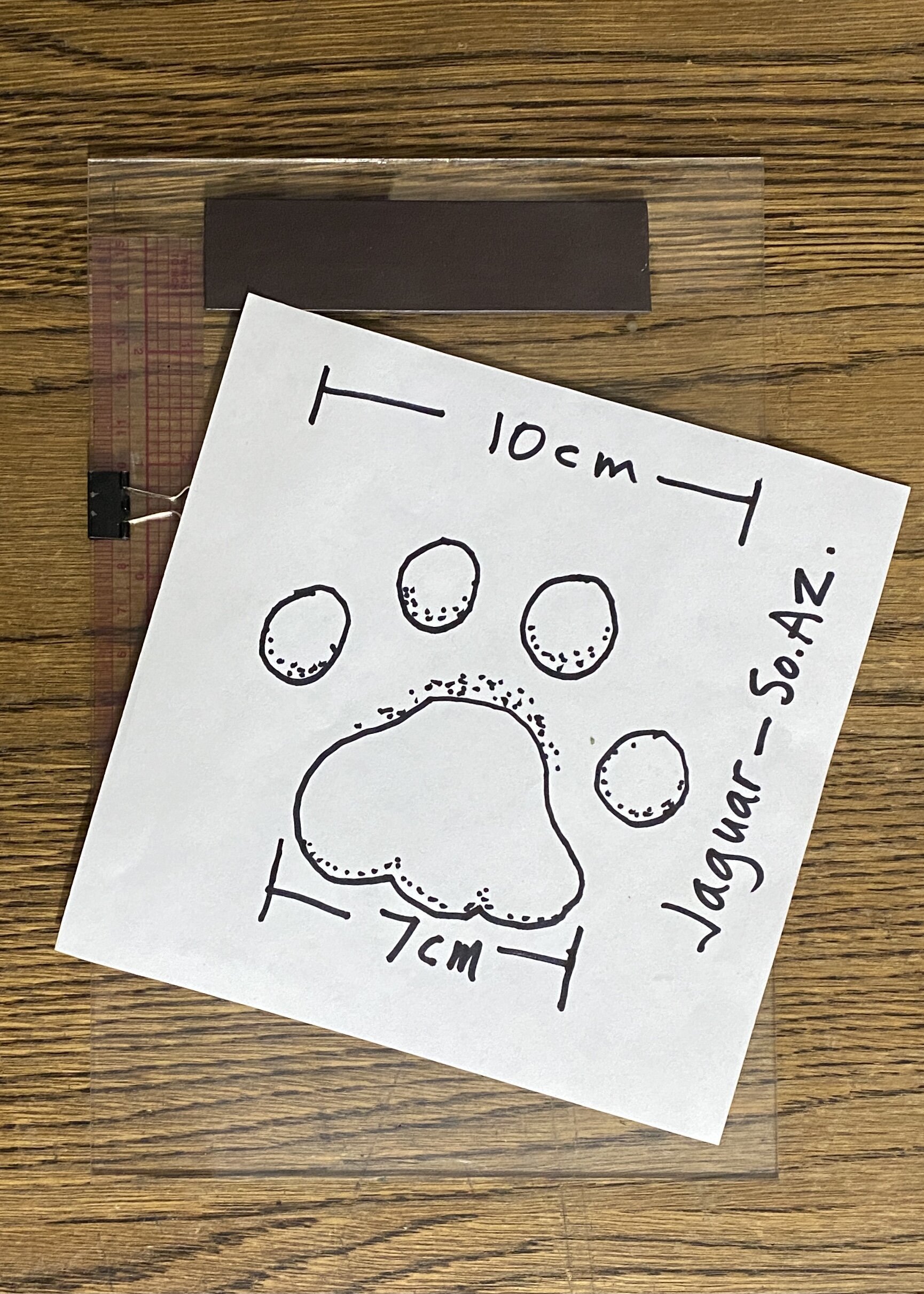
Mountain lion track (southern Arizona).

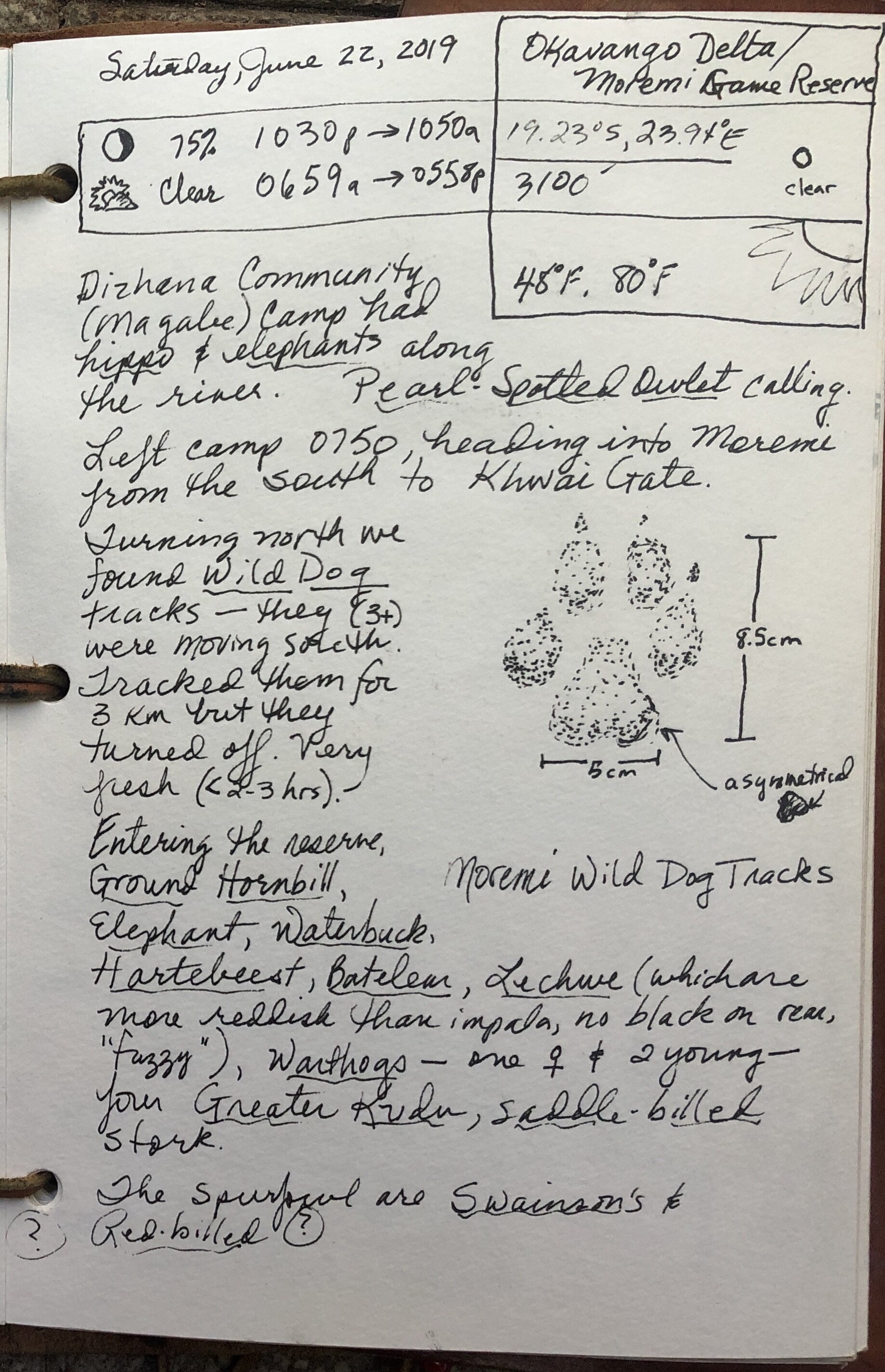
Wild Dog tracks (Botswana, Okavango Delta).

Mountain lion tracks (southern Arizona).
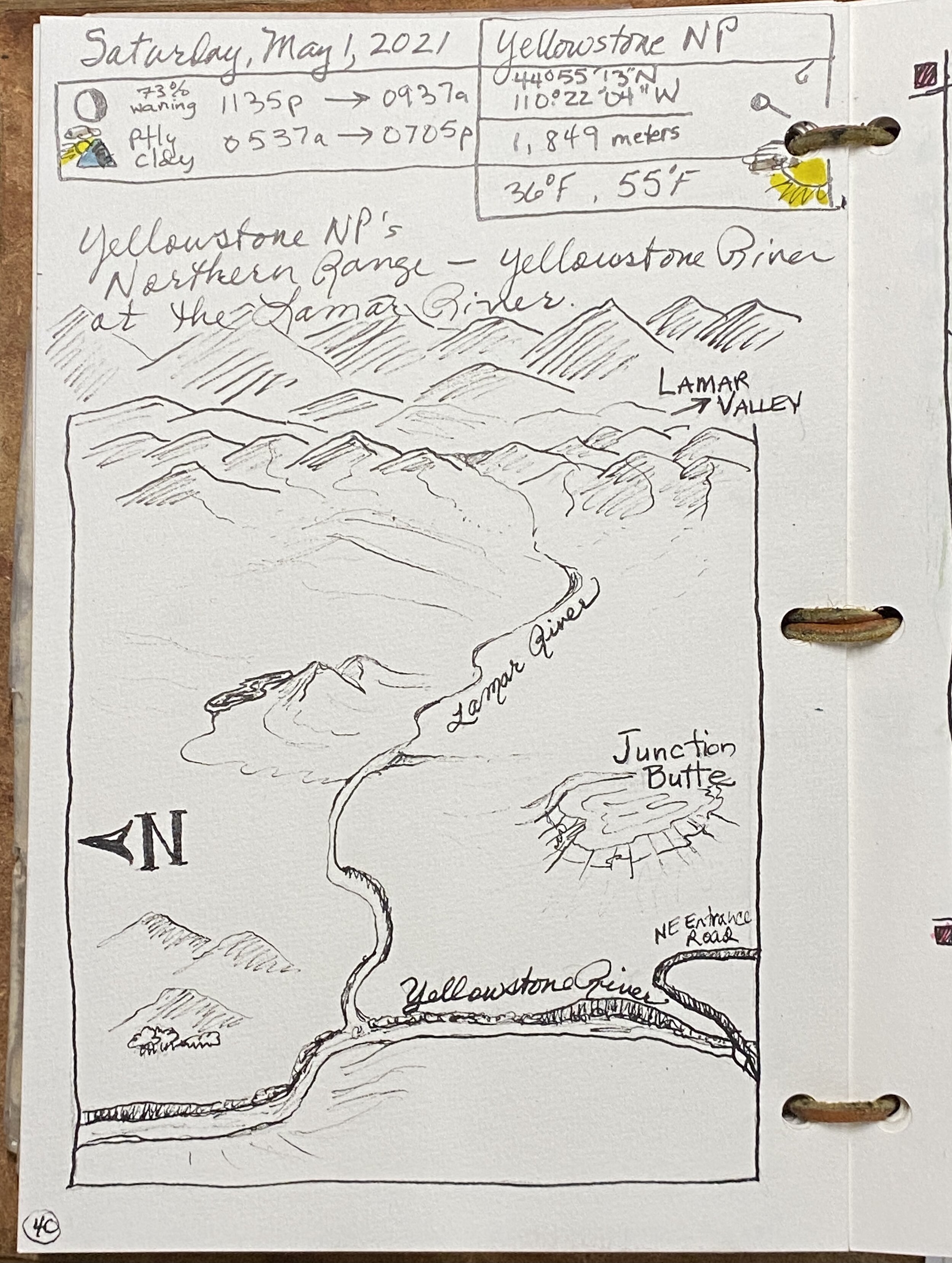
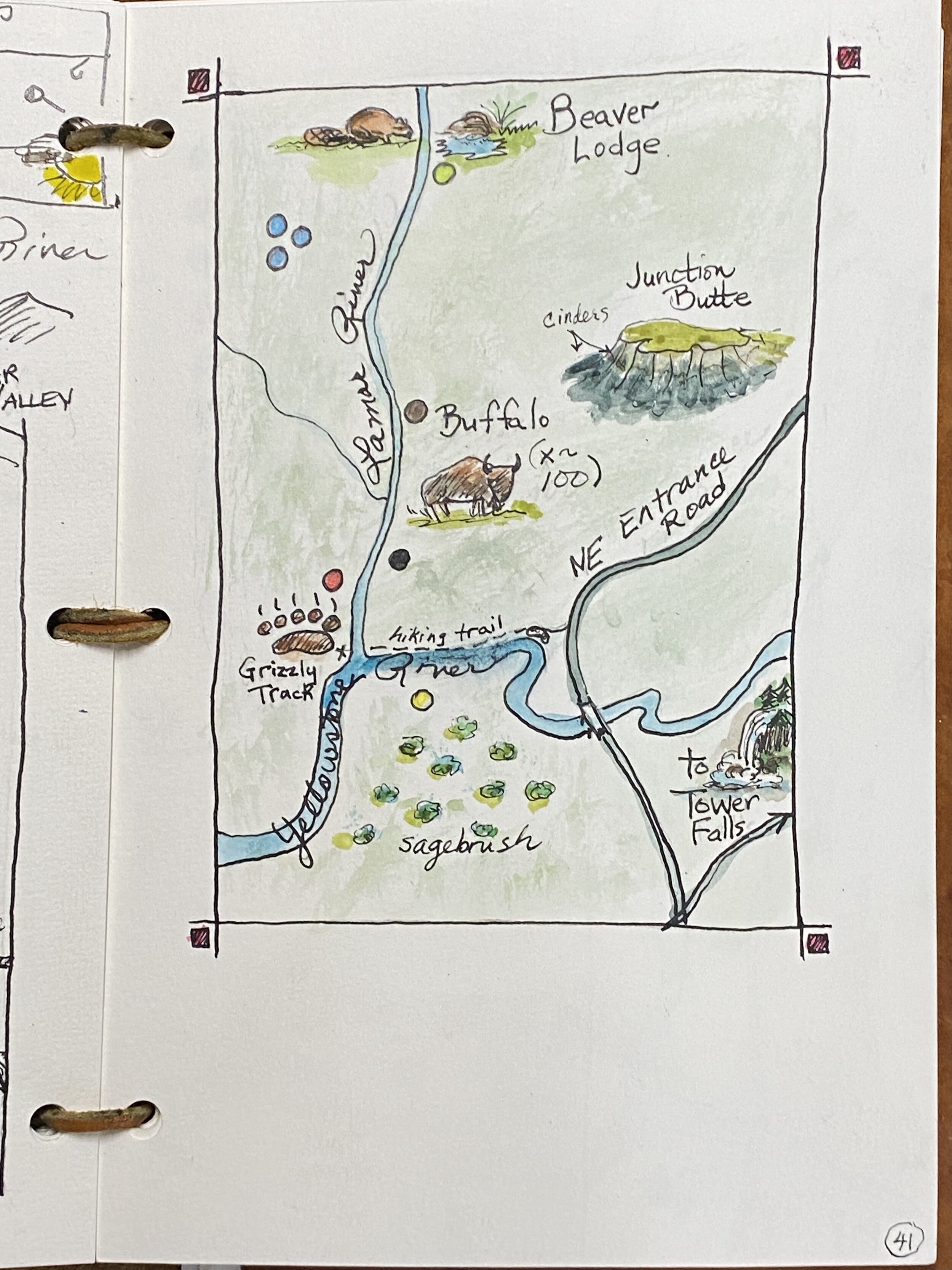
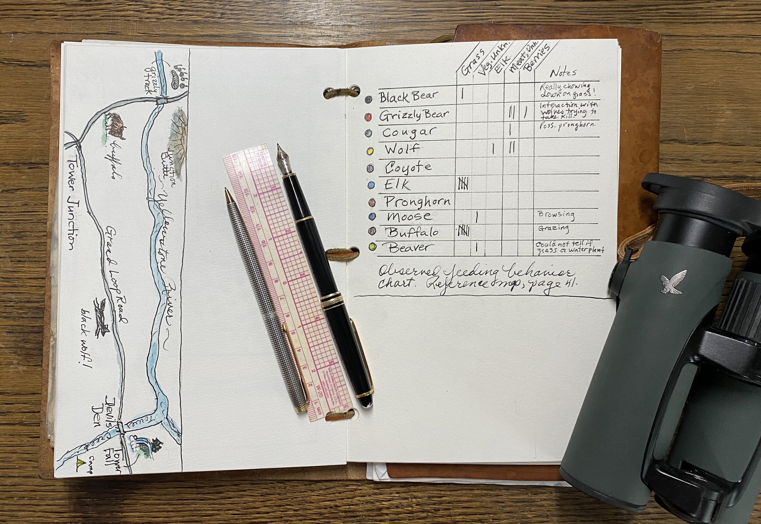
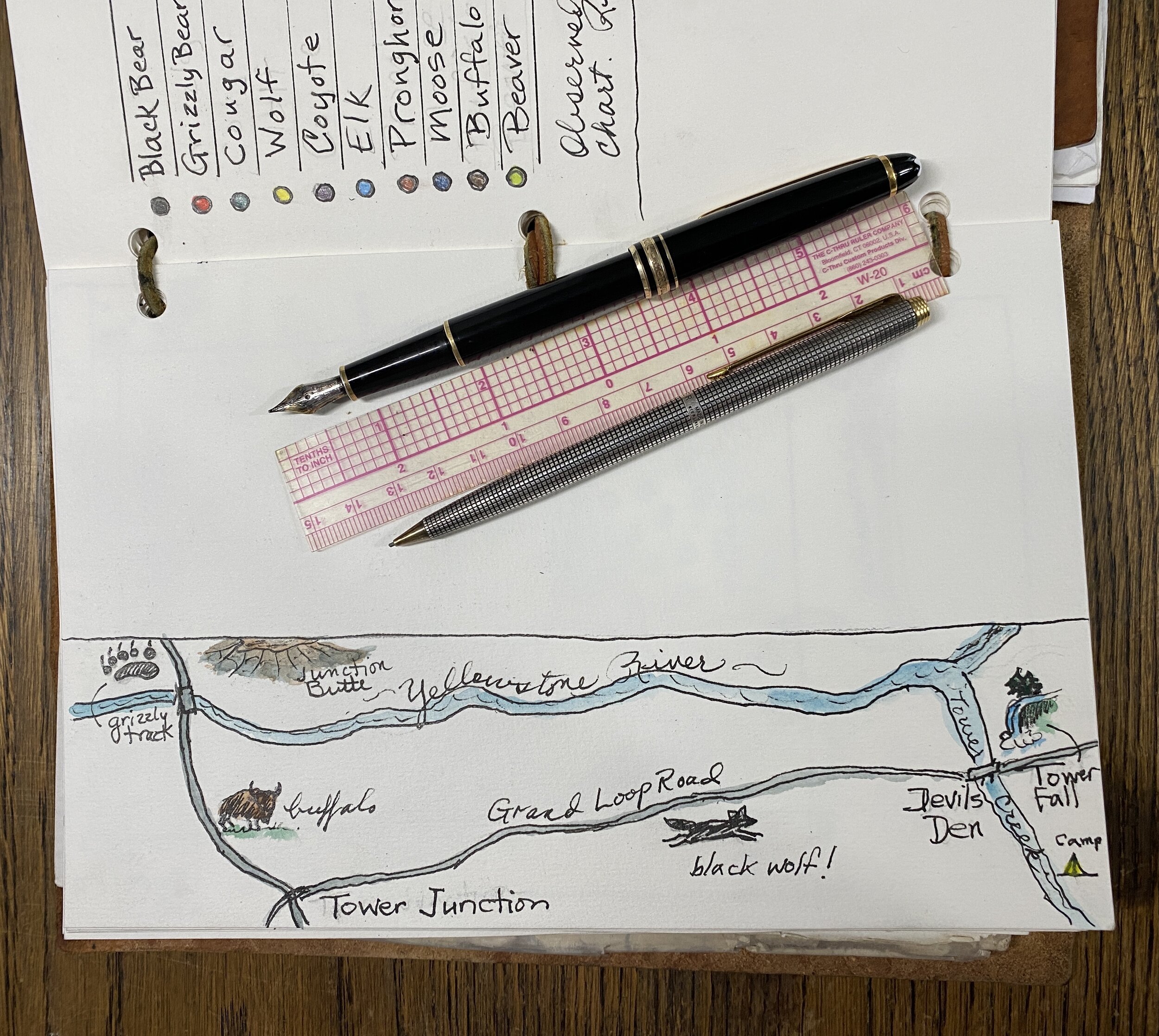
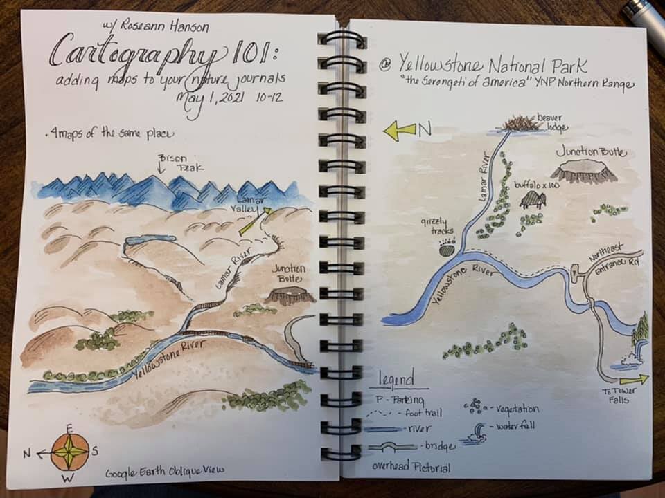
Field Arts Workshop: Cartography 101 for Field Notebooks

Let’s explore cartography for your nature journals and field sketchbooks. Adding maps is fun and although they can be challenging and even intimidating, they will greatly enhance not only your journals but your understanding of a place.
Traditional maps with features such as contours and shading to show relief
Linear maps that unfold or scroll from point-to-point on an exploration of a place or region
Picture-highlight maps of a place, including non-scale ideas for quick mapping
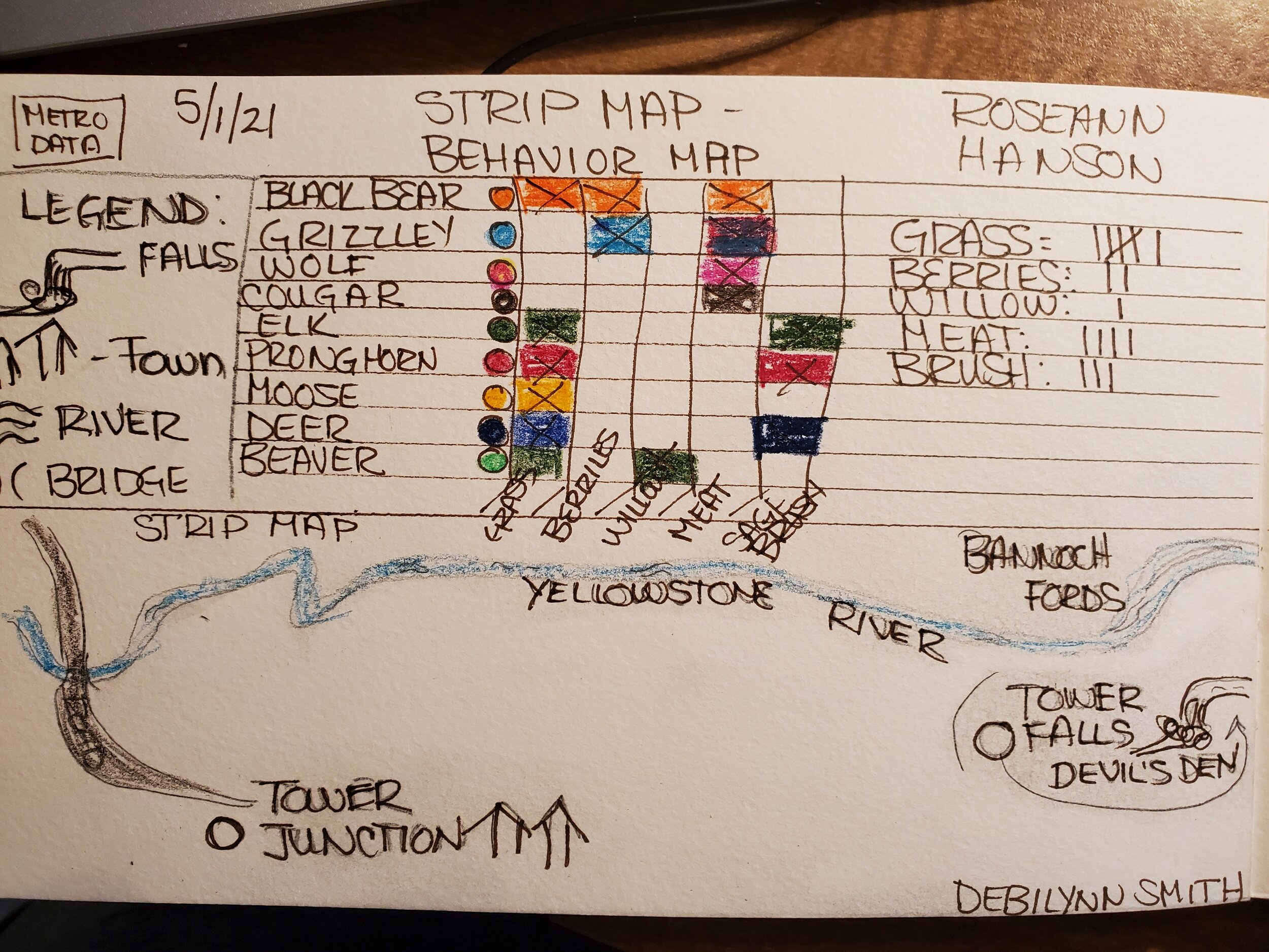
Behavior maps depicting such things as an animal foraging or defending a territory
Length: 2 hours
Resources from the Workshop
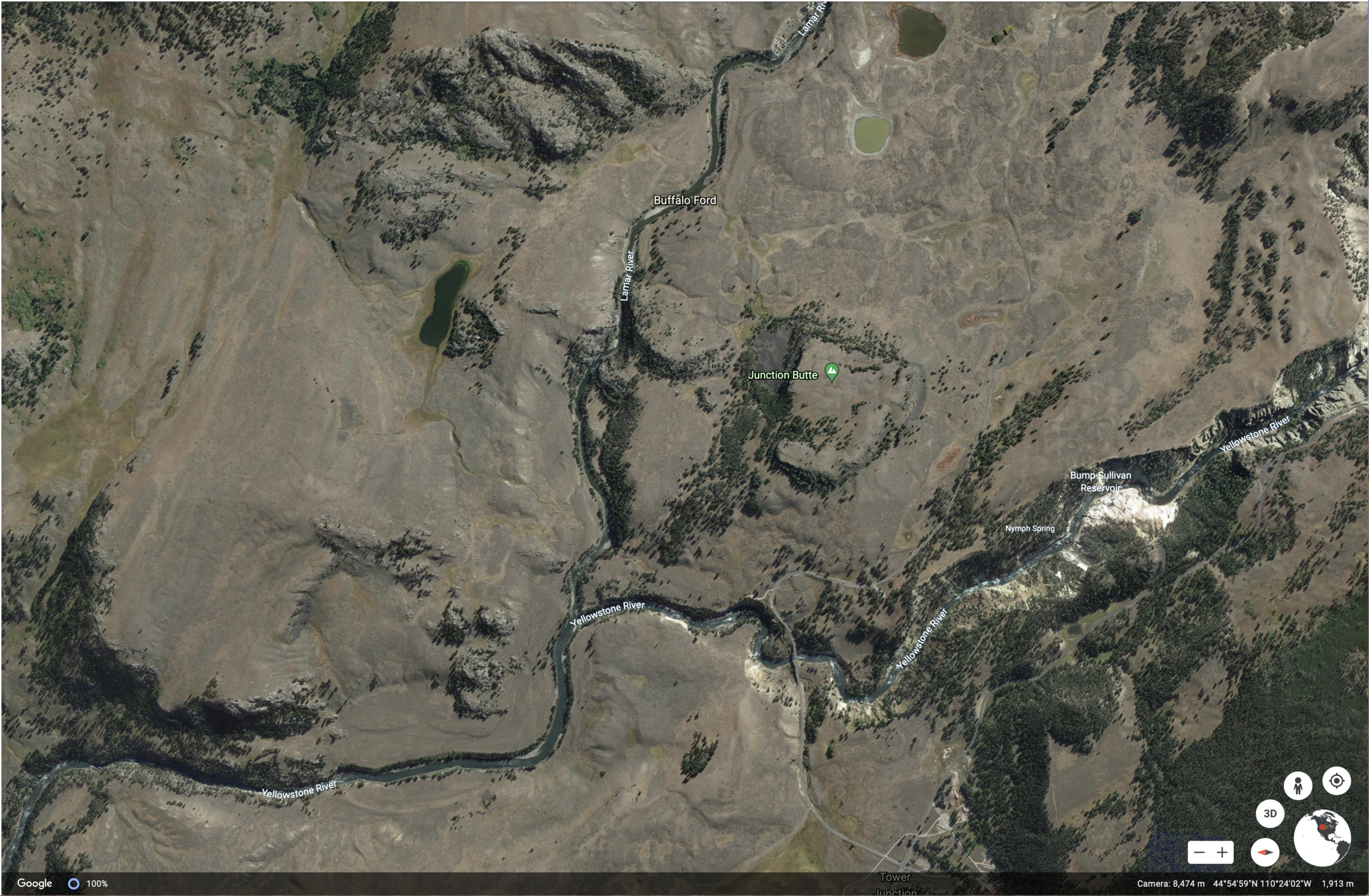
Google Interactive View of the Northern Ranges, Yellowstone:
Downloads (Cartographic Elements and Features):

JPG of cartographic elements and features (printable for your journals):
PDF of cartographic elements and features (larger format):
Video of Yellowstone Northern Ranges:
https://www.nps.gov/media/video/view.htm%3Fid%3D17806168-1DD8-B71B-0BE946127DB84B95
METADATA AND NATURE DATA for MAPPING LOCATION:
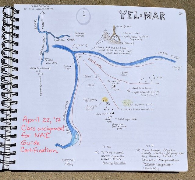
Location: Confluence of Yellowstone River and Lamar River, “Yell-Mar,” in the Northern Ranges
Latitude: 44 degrees 55’ 13” N
Longitude: 110 degrees 22’ 04” W
Elevation: 1849 meters (6066 feet)
Low:36 degrees F
High: 55 degrees F
Sunrise: 1135 am
Sunset: 0937 pm
Moon phase: 73% waning
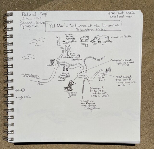
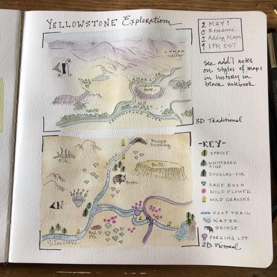
ROSEANN’S FIELD NOTES PAGES from THE WORKSHOP:
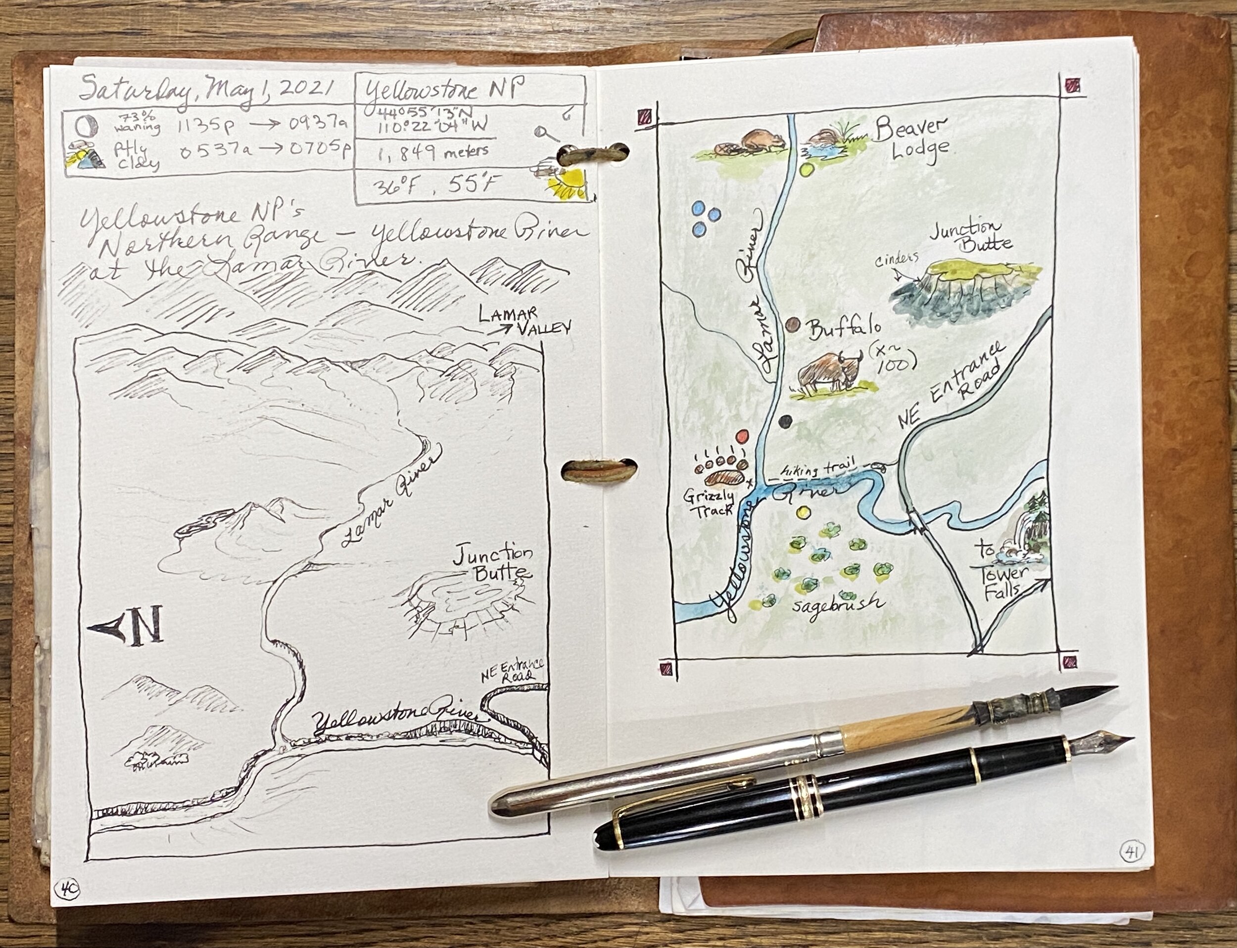
You can find my list of minimalist colors and tips on color mixing here: https://www.exploringoverland.com/field-arts-tutorials-list/2020/7/5/minimalist-watercolor-for-nature-journaling
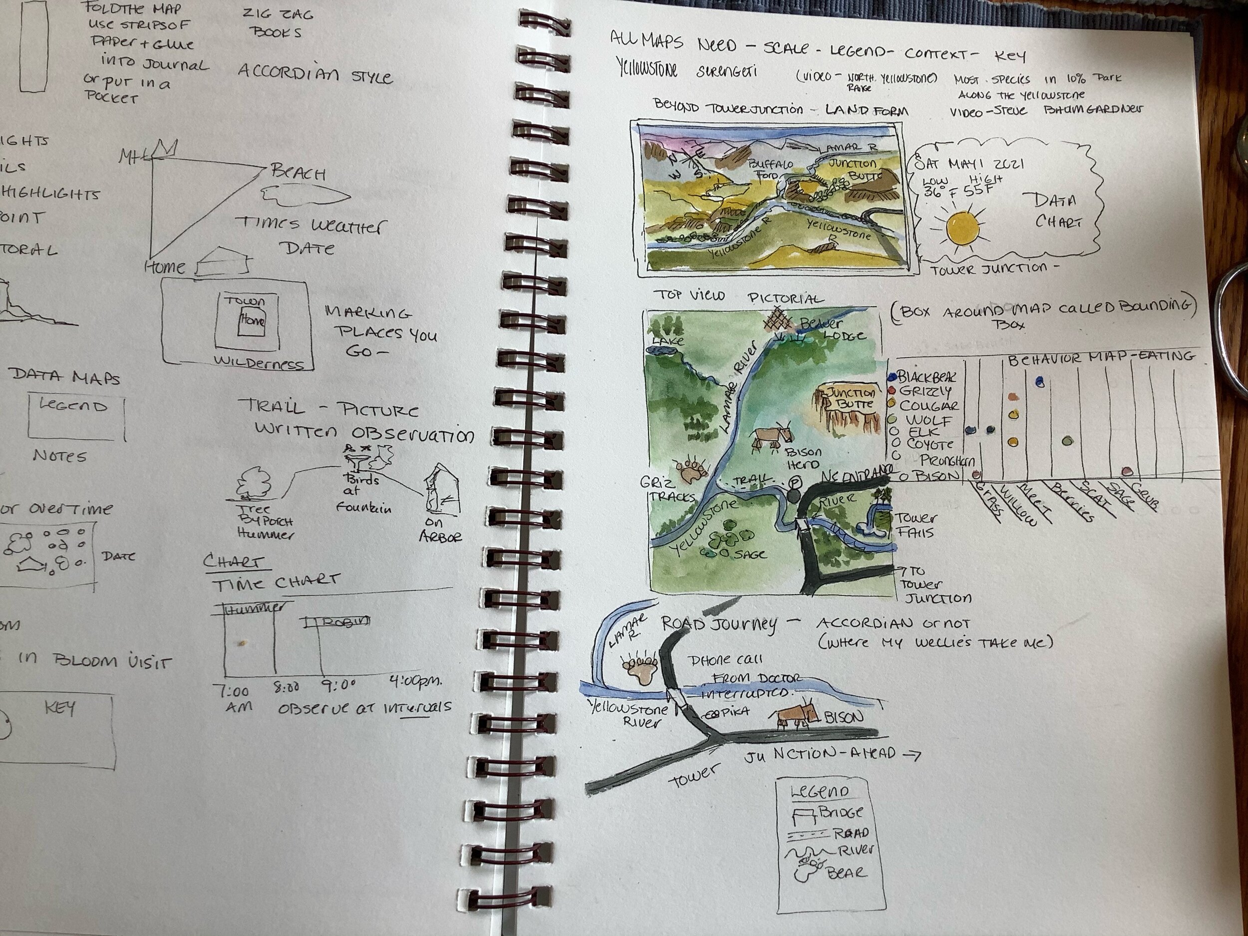
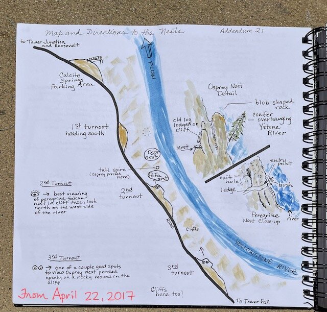
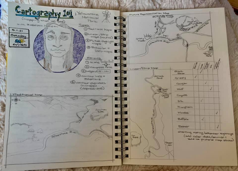
1. Traditional Map - original view

2. Pictorial Map - original view

3. Linear or Strip Map - original view
4. Behavior Map - original view
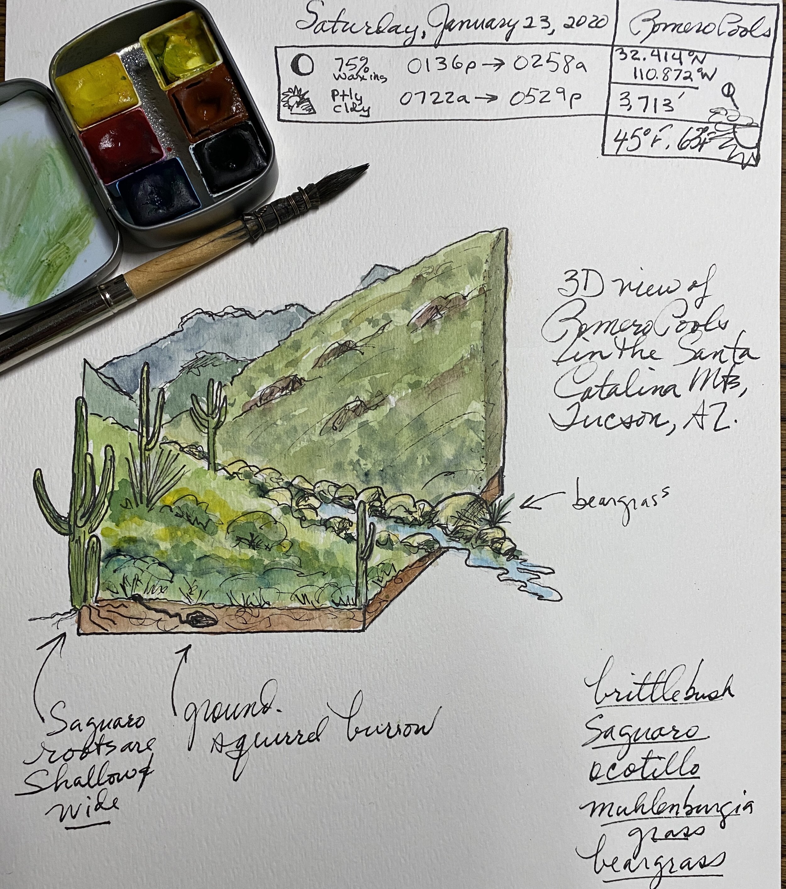
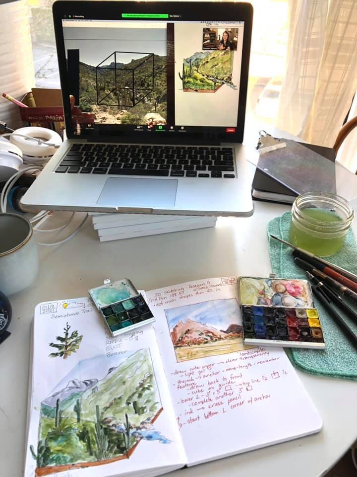
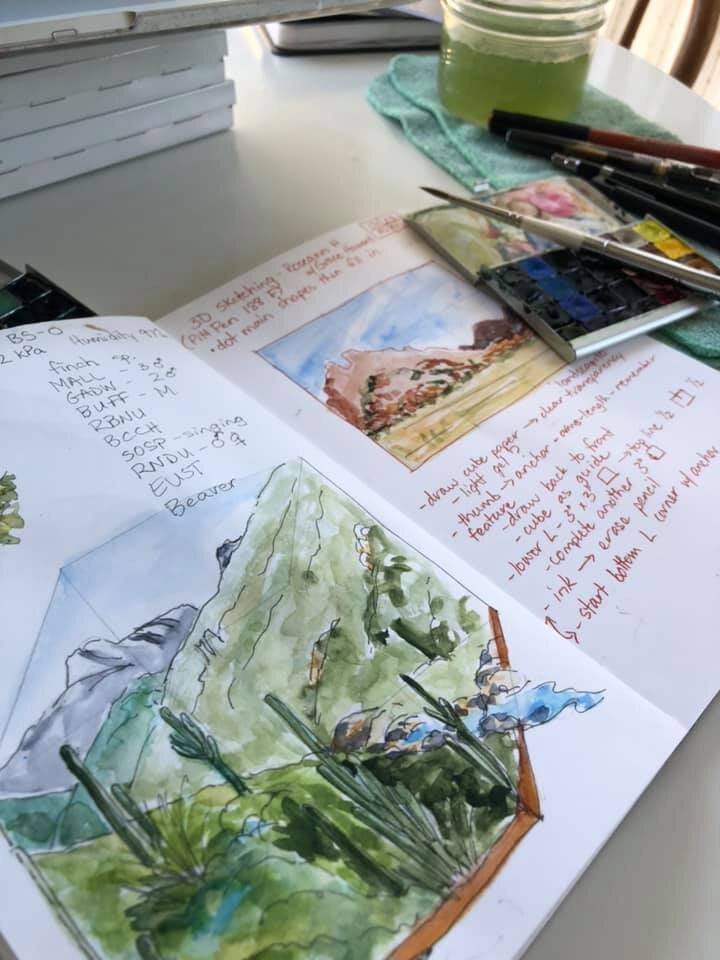
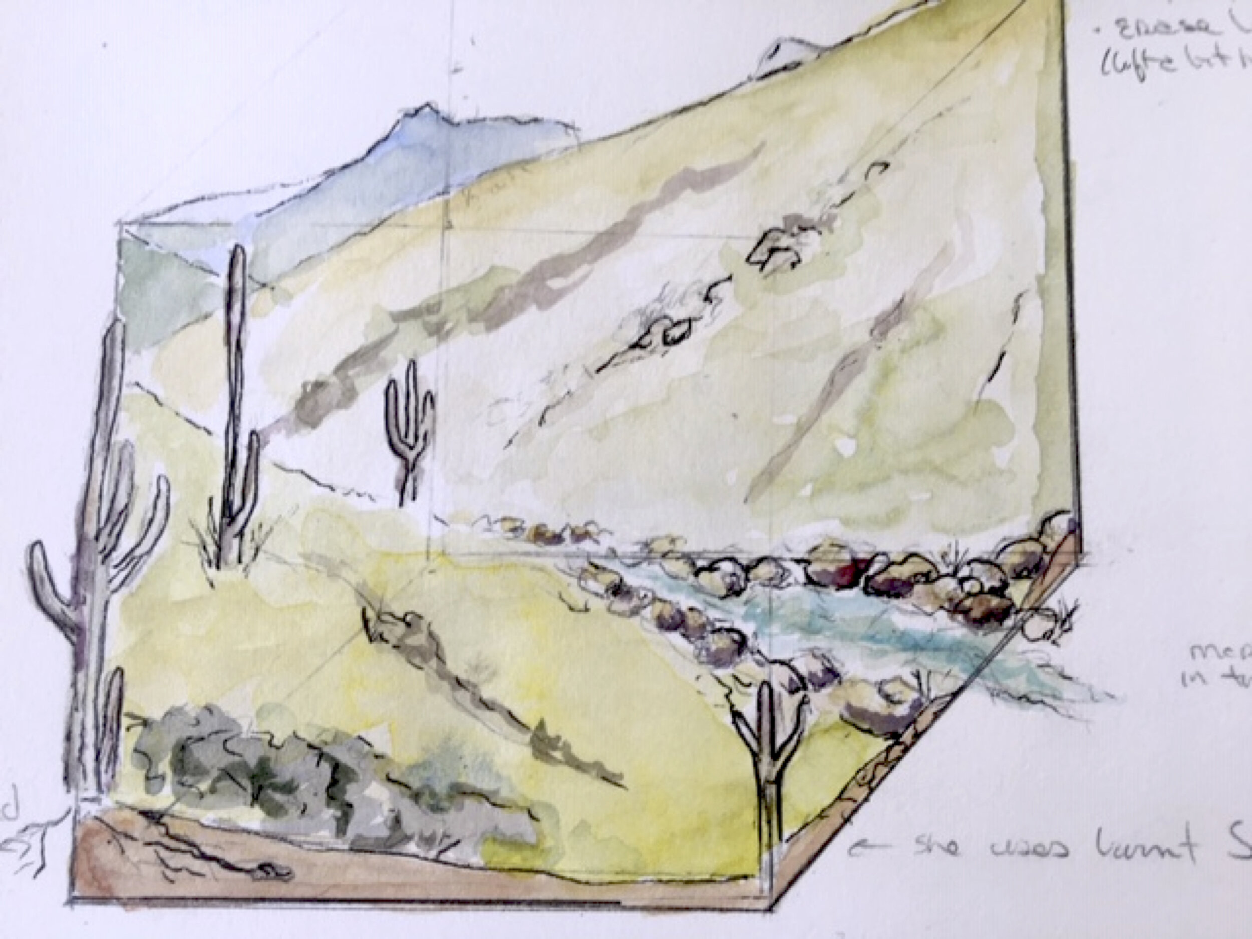
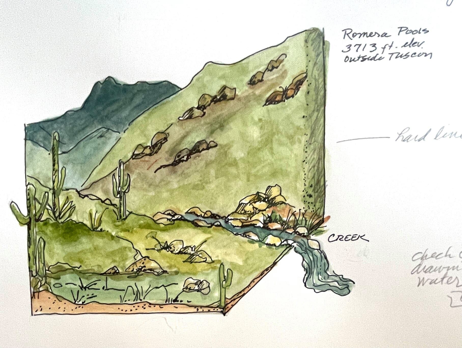
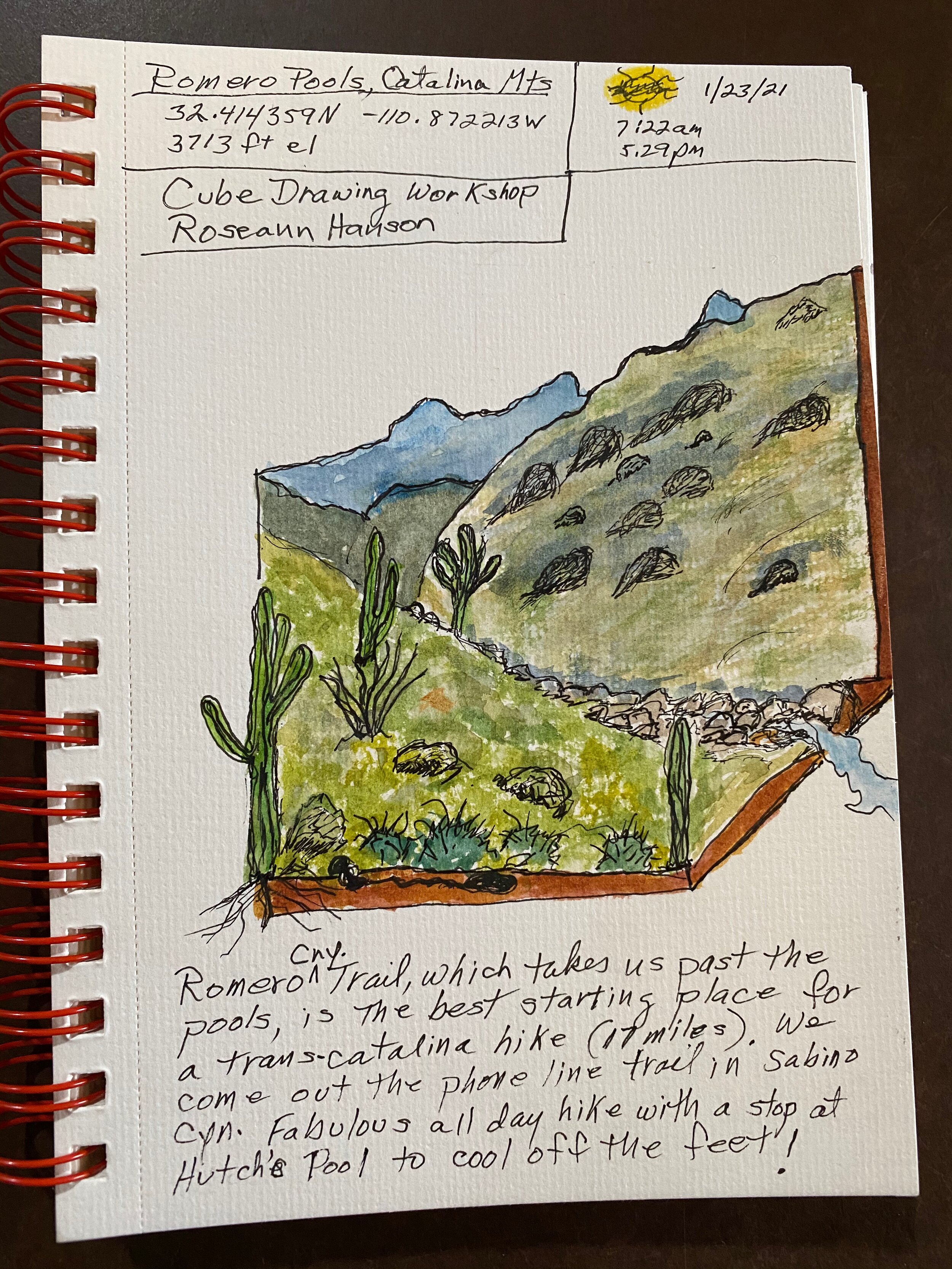
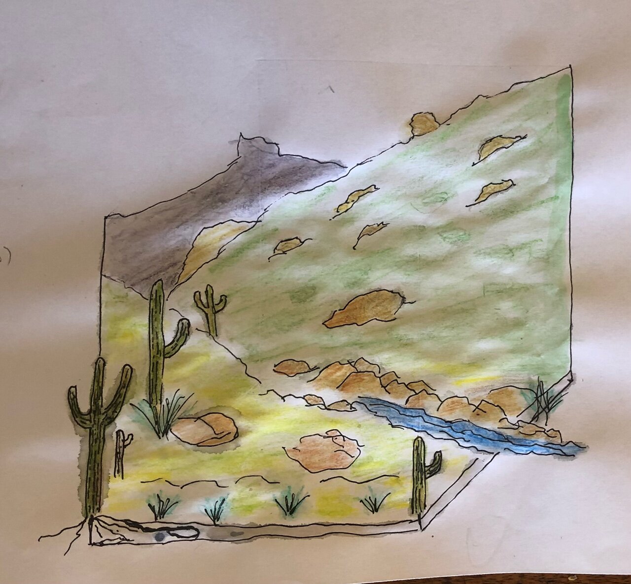
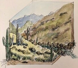
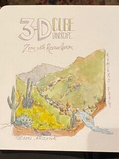
Using Grids: 3D cube landscapes and more
Join me for a free online workshop on how to draw “3-D” landscape cubes — in which you envision taking a giant cutter and pulling a cube out of a landscape, showing the sliced edges and details such as soil and creeks and roots (see here and here for examples). John Muir Laws details them in his wonderful book The Laws Guide to Nature Drawing and Journaling.
These are not easy to do— I struggled with these complex drawings “live” in the field. Where to place the cube, how to envision placing the elements correctly. I always drew mine from photos, then actually printed them and sketched the cube over the photo, or used Photoshop to put a cube over the digital photo.
But with a fun new tool ( the new clear Perspex Palette-Easel ) I will show you how to easily capture a very fun view of a landscape. Make your own (I’ll include instructions), or order one from my shop ($13 with a dry-erase marker or $12 without).
Length: 2 hours
Resources from the Workshop


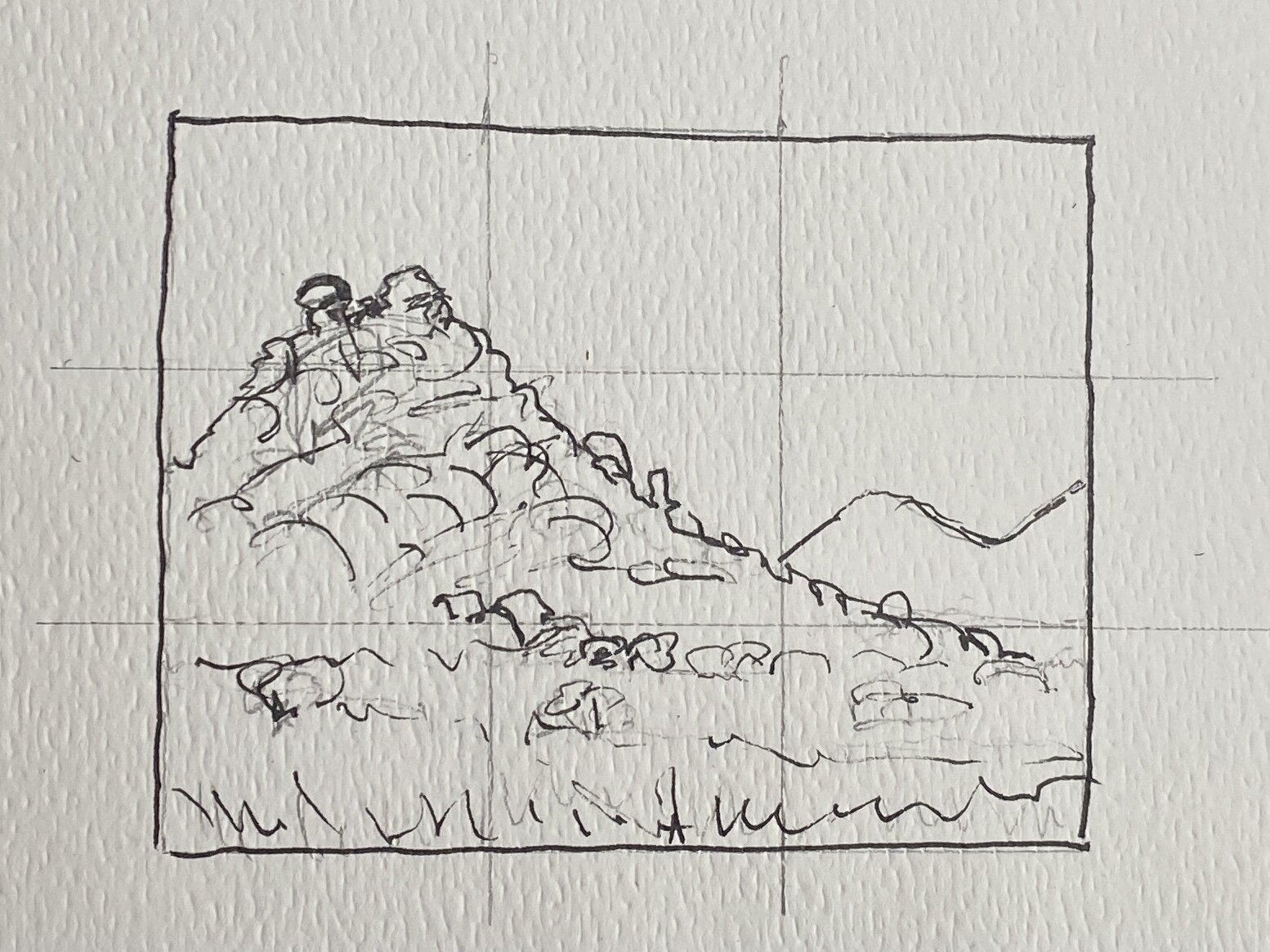
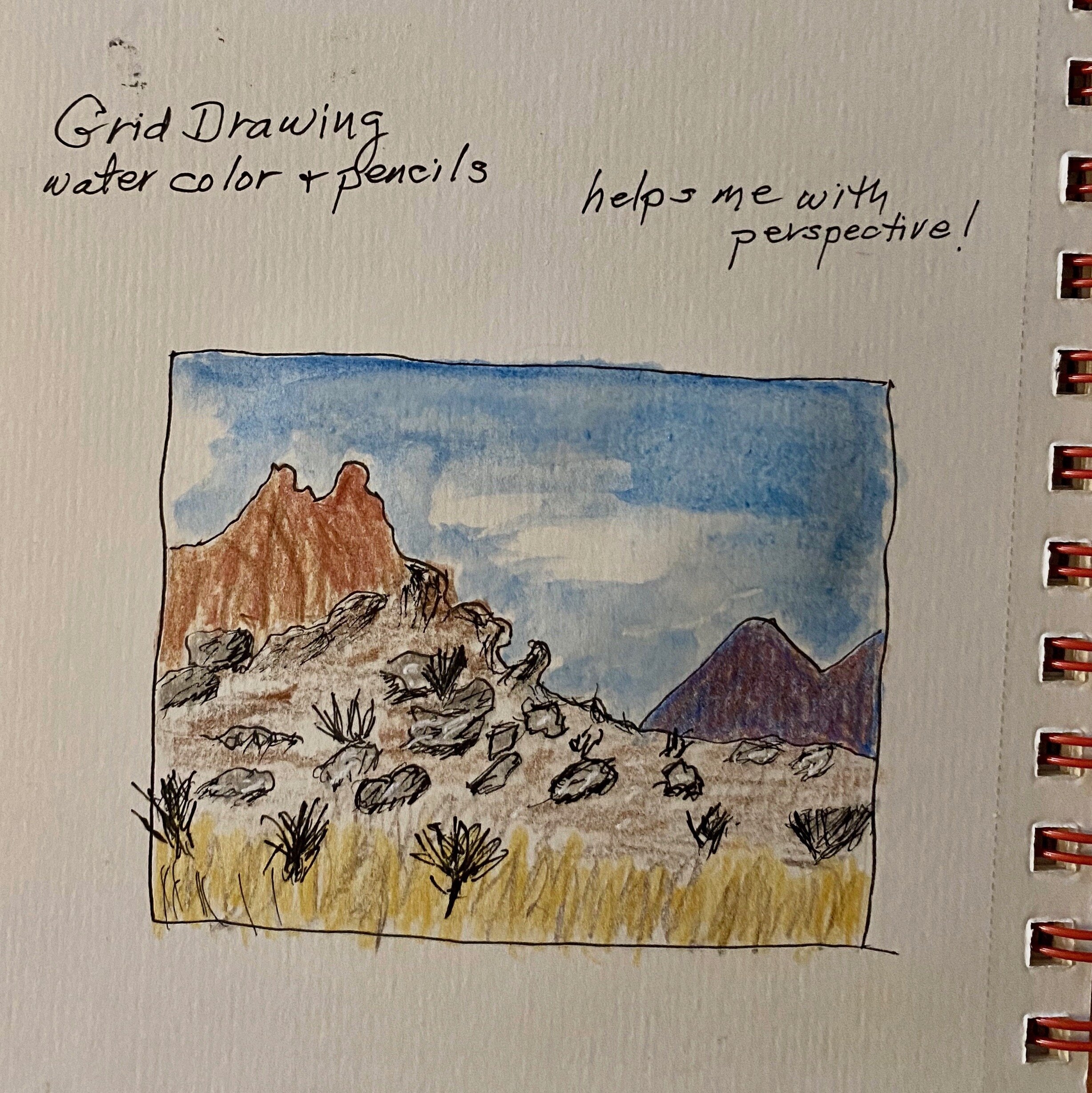
IMAGE FOR PRACTICE DRAWING GRID LANDSCAPITO


IMAGE FOR PRACTICE-DRAWING CUBE LANDSCAPE
METADATA AND NATURE DATA for ROMERO POOLS, SANTA CATALINA MOUNTAINS, TUCSON, ARIZONA, USA:
32.414359 N, -110.872213 W
3713 feet elevation
Sunrise 0722 am
Sunset 0529 pm
Moonrise 0136 pm
Moonset 0258 am
Moonphase 75% illumination / waxing
High / Low temperatures - High 63/ Low 45 (degrees F)

Support free tutorials! Click to contribute to the Tip Jar!
Nature Journal Page Flow
Just starting out nature journaling? Here is a short tutorial on how I begin a nature journal page using metadata (the “data that goes with data” to give it relevance by grounding it in time / place / weather) and then use a prose entry to get into the “flow” before adding a quick sketch.

Here’s an example of a couple of pages from a day in the Okavango Delta, in Botswana. You can see my grid, the way I do the weather and location and moon / sun, then start out with a narrative prose to get warmed up. I add question marks, circled, for things I want to look up later or research more thoroughly (like why do zebras flap their lips!?). The sketching need not be “perfect”—notice I used boxy stick-like figures to approximate the impala’s gait (I call this “drawing like a paleo-journaler” in my book). Keeping lists for nature data is also important, so I almost always do a bird or “wildlife” list on one side and add to it through the day. Drawing boxes is also a great way to add interest and break up prose on a page. You don’t even have to fill them first—just draw one, and write around it, wait til something sparks your interest.


SUPPORT FREE TUTORIALS—CONTRIBUTE TO THE TIP JAR!